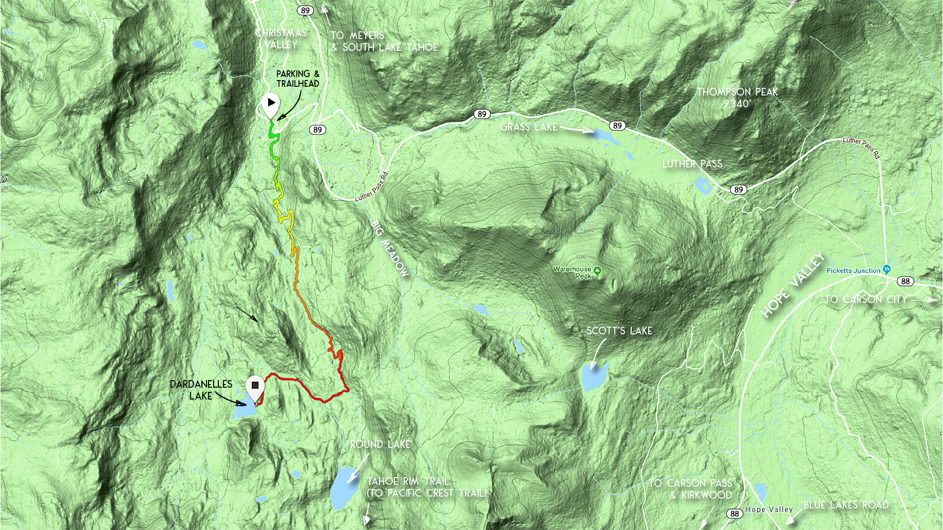
The hike to Dardanelles Lake along the Christmas Valley Trail is a lesser known hike in South Tahoe. This is due to the fact that its trailhead is off-the-beaten-path. Unless you’ve read about it in a guidebook or randomly stumbled upon the trailhead, you’d probably never know it existed. Therefore, you don’t need to travel far from town in order to hike a relatively remote trail!
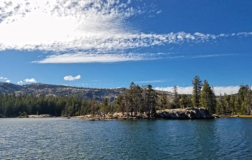
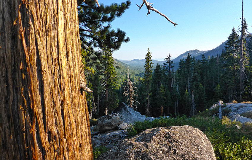
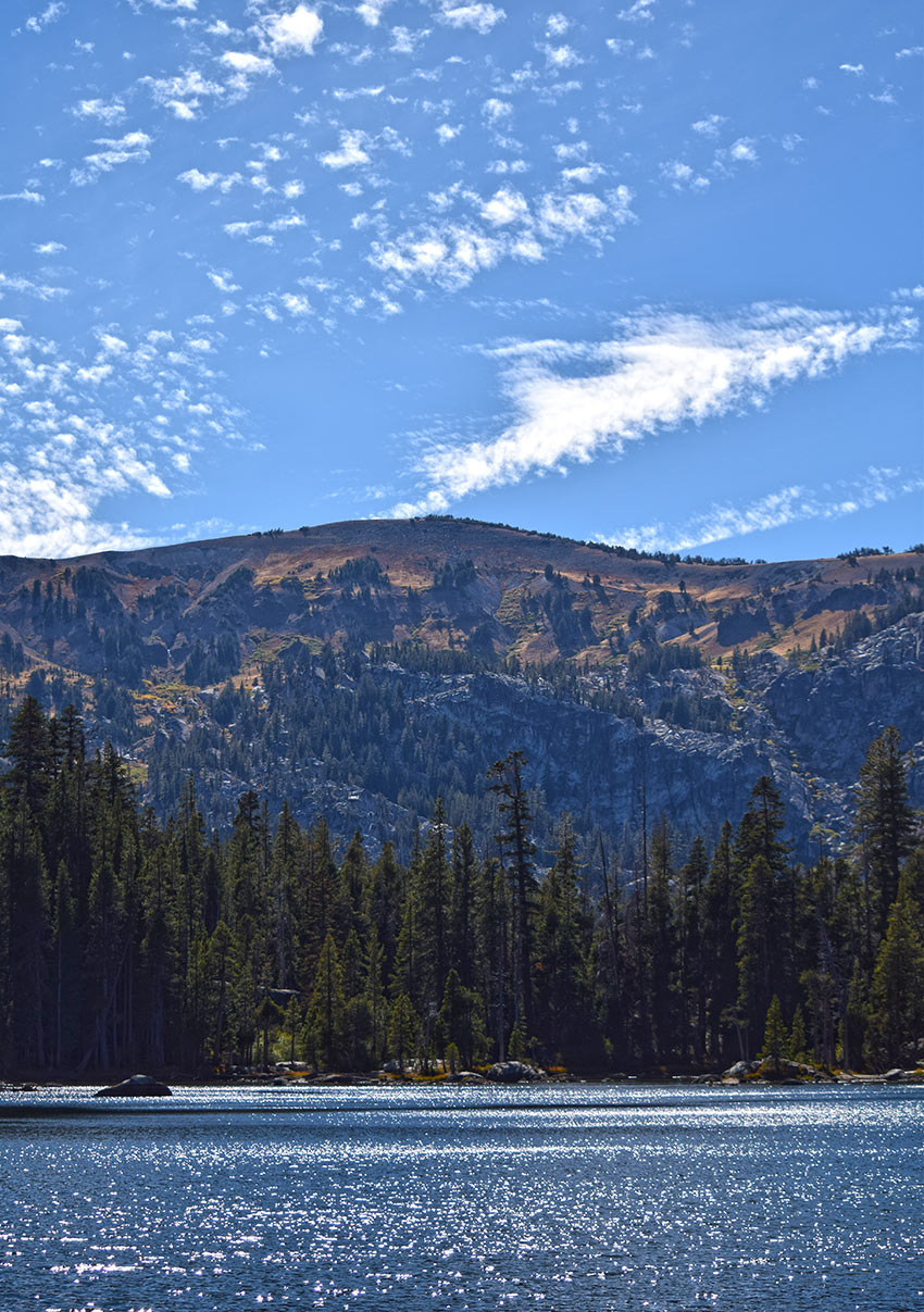
Keep in mind that there are limited panoramic views along the Christmas Valley Trail. The majority of the hike travels through the forest. However, Dardanelles Lake itself is surrounded by a picturesque backdrop thanks to the geological diversity of Meiss Country.
Since this trail features so much forest, it’s an appealing route for windy and otherwise inclement days. Basically, you’re protected from the elements thanks to the forest.
Dardanelles Lake is a fantastic summer swimming locale. It features sandy sections of beach as well as granite slabs on which to relax.
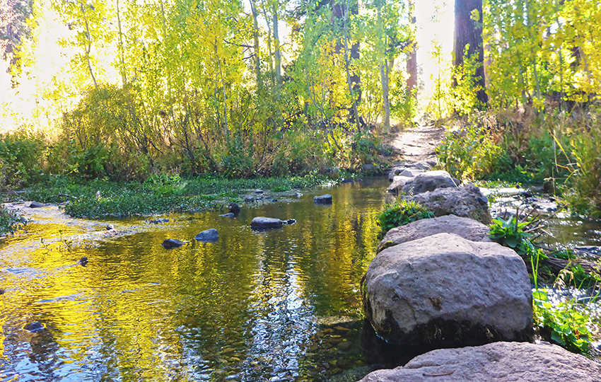
In this region you can find an abundance of wildflowers and Sierra Nevada birds during the warmer months. And, in the fall, you’ll be treated to amazing colors thanks to the aspens and willows that grow in various sections along this trail.
Dardanelles Lake is also a favorite location of Tahoe locals for short overnight backpacking trips. Again, it’s out of the way, but not far from home.
Support Tahoe Trail Guide with a financial contribution via PayPal (single contribution) or Patreon (reoccurring contributions). Your support of Tahoe Trail Guide is very much appreciated!

Dardanelles Lake and Christmas Valley Trail Data (approximations):
- Location: South Tahoe – Christmas Valley – South Upper Truckee Road
- Category of Hike: Day Hike
- Total Mileage: 10.5 miles (out-and-back)
- Total Elevation Gain: 1,700 feet
- Highest Point: 7,810 feet
- Trail Conditions: Alternating between hard packed and sandy soil
Considerations for Hiking to Dardanelles Lake via Christmas Valley Hiking Trail:
- The distance presented on most maps of the Christmas Valley Trail (aka Lake Valley Trail) to the Dardanelles Lake turnoff indicate that it’s 2.8 miles long, but this is incorrect as the true distance is 4 miles (see below for more details)
- In my experience they’ve always been respectful, but the Christmas Valley Trail is a favorite among mountain bikers so be mindful about your surroundings so as to avoid startling or colliding with one another
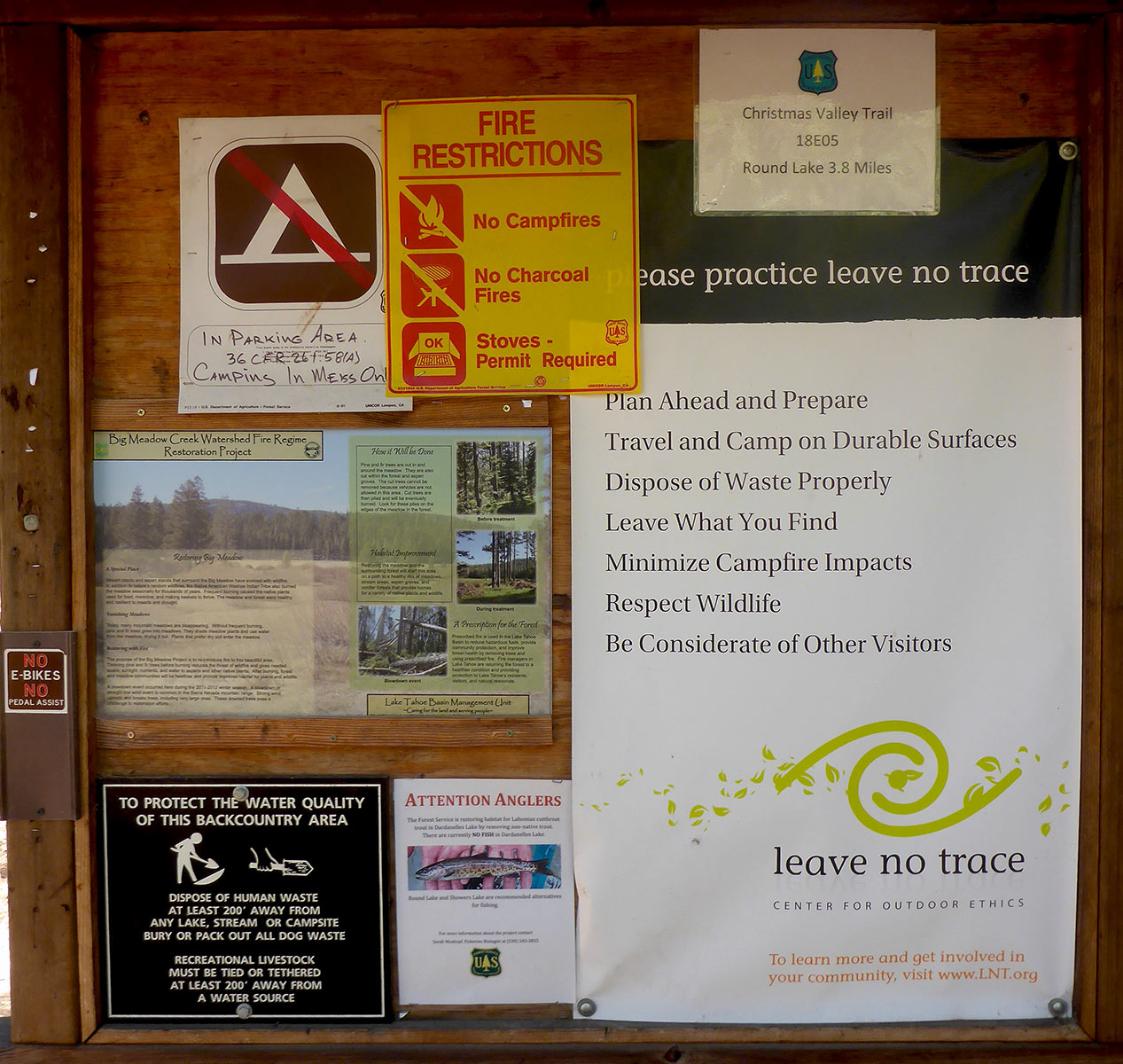
- Adhere to all Leave No Trace principles
- There are few trail signs and markers on public lands in the Tahoe region, so unless there are tracks to follow, the correct route may be difficult to identify—when in doubt, turn back
- Be prepared for inclement weather and carry plenty of warm clothes, food, and water
- Leave an itinerary of your plans with someone who’ll call emergency services if you don’t return by your prescribed time
- Dogs are allowed, but keep them on leash and pick up after them
Parking Directions for Hiking to Dardanelles Lake:
Since this trailhead sees relatively little use, parking is usually abundant. Also, there aren’t any fees associated with parking at the Christmas Valley Trail trailhead.
There are two ways in which to find the trailhead to the Christmas Valley Trail.
Parking Option #1
From Meyers, CA, drive south 4 miles along SR 89. Look for the South Upper Truckee Road sign on the west side of SR 89.
Take a right (west) on this single-lane road and travel downhill just shy of a mile to the trailhead.
The parking area at the trailhead consists of some dirt turnouts. And there’s a Forest Service sign indicating that you’re entering Meiss Country. The sign board also features additional information regarding recreating in the area.
Please note that the single-lane road you’ll be turning on from SR 89 features tight switchbacks. So, be mindful of other vehicles and mountain bikers.
Even though there’s an actual sign indicating South Upper Truckee Road, it’s easy to miss. I’ve driven this road numerous times over the years. And, I still occasionally miss it because you can pass the junction in the blink of an eye.
For those of you who’ve reached the Big Meadow Trailhead you’ve gone too far. Backtrack until you find that small road leading downhill.
Parking Option #2
Drive along South Upper Truckee Road directly from HWY 50. The start of South Upper Truckee RD is on HWY 50, just west of the Upper Truckee River bridge in Meyers, CA.
Or, you could turn onto Portal Drive on the south end of Christmas Valley (from SR 89). Then continue south along South Upper Truckee Road until you reach the trailhead.
You’ll recognize the trailhead by the informational signs and the dirt turnouts. You’ll know you’ve gone too far if the road narrows to a single lane and you find yourself heading uphill. This narrow road leads back to SR 89.
Driving along South Upper Truckee Road is not the fastest way in which to reach the trailhead. However, it’s a pleasant drive. And if you start at HWY 50 you’ll get to travel past the historic Celio Ranch.
The parking area and trailhead for hiking the Christmas Valley Trail to Dardanelles Lake is located at the south end of South Upper Truckee Road.
Here’s a map to help you find the trailhead for hiking to Dardanelles Lake via the Christmas Valley Trail.
Disregard the “Bridge Road” aspect of this marker. I couldn’t embed this map any other way than to add two locations for which to travel between. This trailhead is so remote that Google Maps doesn’t yet recognize it!
Travel to Dardanelles Lake via Christmas Valley Hiking Trail:
The Christmas Valley Trail trailhead is located at the southern end of South Upper Truckee Road.
From the trailhead, hike 4 miles gradually uphill to the turnoff for Dardanelles Lake. This section will climb a little over 1,400 feet in elevation.
There’s a signpost at this t-intersection indicating that Dardanelles Lake is to the west. From this junction, travel 1.25 miles west to Dardanelles Lake.
Since this is an out-and-back hike, you’ll return to your vehicle by hiking along the same trail.
For bonus miles and to access other aspects of Dardanelles Lake, follow the footpath around the lake.
You can’t completely circle the lake as the cliffs on its southern side prevent this. However, there’s plenty of additional terrain to explore if you choose to hike beyond the initial access point on the lake’s eastern side.
Inaccurate Trail Data about Hiking Dardanelles Lake
Most trail maps, guidebooks, and articles about hiking to Dardanelles Lake via the Christmas Valley Trail incorrectly list the total (round-trip) distance as being 8 miles. Therefore, their one-way mileage is 4 miles.
This is not true.
The problem is those incorrect sources list the distance between the trailhead and the Dardanelles turnoff as being 2.8 miles. However, the actual distance is 4 miles.
I’ve hiked this trail many times. And I’ve always recorded a one-way distance from the trailhead to the Dardanelles Lake turnoff as being exactly 4 miles.
Then, you have another 1.2 miles to hike from that junction before reaching Dardanelles Lake. So this brings your total (round-trip) mileage to about 10.5 miles (not 8 miles).
Round Lake is also about 1 mile beyond that Dardanelles Lake junction. So, again, the one-way distance of 3.8 miles that the FS listed (see photo) was incorrect. This is because that distance was, again, based on the inaccurate Christmas Valley Trail distance of 2.8 miles.
I realize the difference between 2.8 and 4 miles (2.4 miles round-trip) won’t break anyone. However, this additional mileage literally adds another full hour to your hike. And, this may or may not fit into your plans for the day.
Alternate Route to Dardanelles Lake
An alternate and slightly shorter route to Dardanelles Lake is to begin your hike at the Big Meadow Trailhead. It’s about 2.5 miles from that trailhead to the junction that leads to Dardanelles Lake. Then you’ll have the 1.2 miles to hike to Dardanelles Lake upon reaching the turnoff from the Christmas Valley Trail.
Use the map for the hike to Round Lake to figure out this slightly shorter route.
If you’re on the fence about which trail to take, these are my reasons for hiking the Christmas Valley Trail:
- I already use the Big Meadow Trailhead for so many other hikes.
- Parking is never full on South Upper Truckee Road.
- There are far less people that hike the Christmas Valley Trail.
Do you have other insight, feedback, or trail updates about hiking Dardanelles Lake?
If so, please post it in the comment section below for the benefit of everybody 🙂
Thank you for the clarification on the mileage! We hiked this yesterday and it seemed considerably longer than any of my trail books said! Beautiful! But yes, significantly longer than advertised! My iPhone, FWIW, actually recorded 12.9 miles R/T!
Hey Natasha,
Thanks for confirming that this trail is much longer than typically advertised everywhere else 🙂 Although, I may have to check the mileage again to see why there would be such a discrepancy between your iPhone and my GPS watch in total distance. The hike to Dardanelles Lake is definitely a locals’ favorite, particularly for relatively easy overnight backpacking trips. It’s a bit more remote than Round Lake (nearby) and, like you said, is really beautiful.
Thanks again for the feedback. And stay safe out there!
I hike to Dardanelle and Round Lakes today (from Big Meadow TRT trailhead) and found your write-up to be very helpful. Dardanelles is a beautiful lake!
Hey Dorian,
So glad I could be of service 🙂 Both lakes are definitely beautiful, and I agree that Dardanelles is quite magical!